VeritasJet Map™ — Global Aircraft Performance & Reachability Intelligence
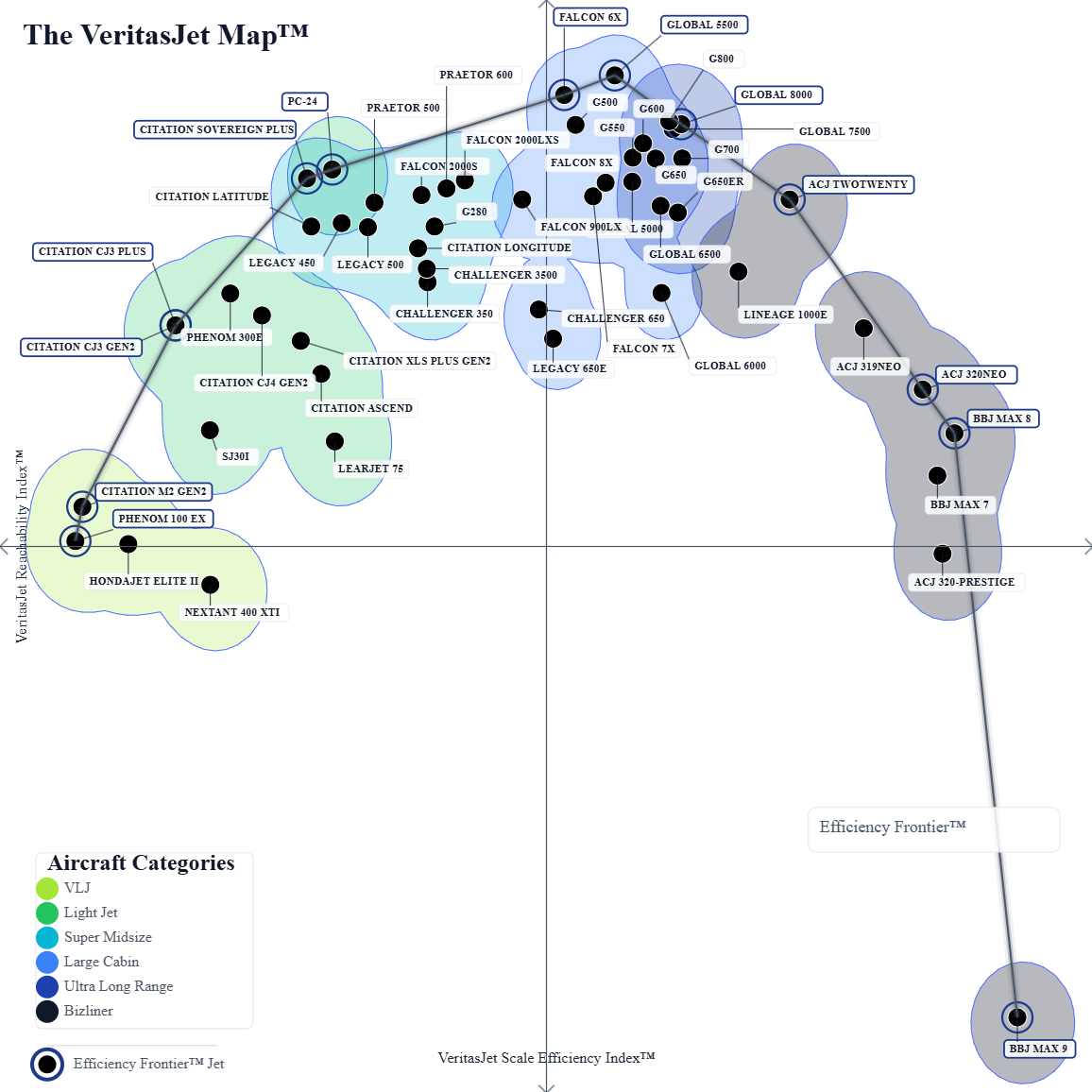
The VeritasJet Map™ is a multidimensional aircraft intelligence system that visualizes real-world jet performance across operational reachability, airport network access, runway flexibility, efficiency, and cabin-scale trade-offs.
Unlike traditional aircraft comparisons based on range or category labels, the VeritasJet Map™ models aircraft as points in a continuous performance space, revealing hidden relationships between design philosophy, mission utility, and operational constraints.
Core Axes
VeritasJet Reachability Index™ (Y)
A data-driven measure of how effectively an aircraft connects to the global airport network under realistic operational constraints, including runway availability, field type, and mission accessibility.
VeritasJet Scale Efficiency Index™ (X)
A composite representation of aircraft scale efficiency, balancing cabin size, range capability, fuel efficiency, and operational trade-offs across aircraft categories.
What the Map Shows
- Real-world mission accessibility, not just maximum range
- Hidden clusters across VLJ, Light Jet, Super Midsize, Large Cabin, and Bizliner segments
- Design philosophy differences between manufacturers
- Efficiency trade-offs between size, reach, and operational flexibility
- Emergent inverted U-shaped performance frontier of aviation scaling
- Frontier aircraft that redefine category boundaries
How to Read the VeritasJet Map™
Higher ↑
Greater operational Reachability and broader airport network reach.
Further Right →
Greater aircraft scale, combining cabin size, range, and mission capability.
Closer to the Frontier
More efficient balance between scale and Reachability. Aircraft here deliver higher utility per unit of size.
✈ Click Any Aircraft
Reveal detailed aircraft intelligence, VeritasJet™ Scores, and operational characteristics.
Key Insight
Traditional aircraft comparisons focus on range and category boundaries. The VeritasJet Map™ instead reveals how scale and Reachability interact as a continuous system.
Aircraft near the VeritasJet Efficiency Frontier™ achieve superior operational reach for their size, while those further away expose the inherent trade-offs between cabin scale, runway access, and mission flexibility.
What is a Frontier Aircraft™?
A Frontier Aircraft™ lies on the VeritasJet Efficiency Frontier™ — the upper envelope of observed reachability for a given level of aircraft scale. These aircraft represent efficient operational trade-offs between accessibility and scale. No alternative aircraft achieves greater reachability at the same or lower scale. Frontier Aircraft™ are not necessarily the largest, fastest, or highest-scoring aircraft. Rather, they define the boundary of efficient solutions within the VeritasJet Map™ performance space.Methodology Note
The VeritasJet Map™ is derived from statistical decomposition of multi-metric aircraft performance data, including reachability simulations, runway constraint modeling, fuel efficiency proxies, and cabin utility scaling.
Based on the VeritasJet framework
Trademark & Intellectual Property Notice
VeritasJet Map™, VeritasJet Reachability Index™, and VeritasJet Scale Index™ are proprietary concepts and trademarks of VeritasJet.